Airborne LiDAR mapping combined with satellite imagery analysis has provided scientists, government agencies and NGOs with a “wall-to-wall” account of the carbon held in Sabah, a Malaysian state on the island of Borneo.
The study, led by ecologists from the Carnegie Airborne Observatory, revealed that more than 40 percent of the forests with the highest carbon stocks aren’t covered by the state’s most stringent protections.
The findings give wildlife biologists the chance to examine how carbon stocks correlate with the presence of biodiversity; NGOs the opportunity to identify new high-carbon areas to set aside under oil palm certification schemes; and the Sabah government the information to determine which forests are the most valuable and therefore need further protections.
Airborne mapping of the northern part of the island of Borneo has revealed that forests there pack some of the highest levels of carbon on the planet, even in a place that has been heavily used by humans.
“I was surprised when we found such high forest carbon stocks in areas with observably high levels of past logging,” said ecologist Greg Asner, who heads the Carnegie Airborne Observatory (CAO) in Stanford, California, and was the study’s lead author.
Asner and a team of colleagues had previously reported in 2016 that 50 of the world’s tallest tropical trees live in Sabah, in Malaysian Borneo. In part, that helps explain why there’s more carbon here “than almost anywhere we have mapped and measured around the global tropics,” he said in an email. “It all comes down to really tall trees packed together spatially.”
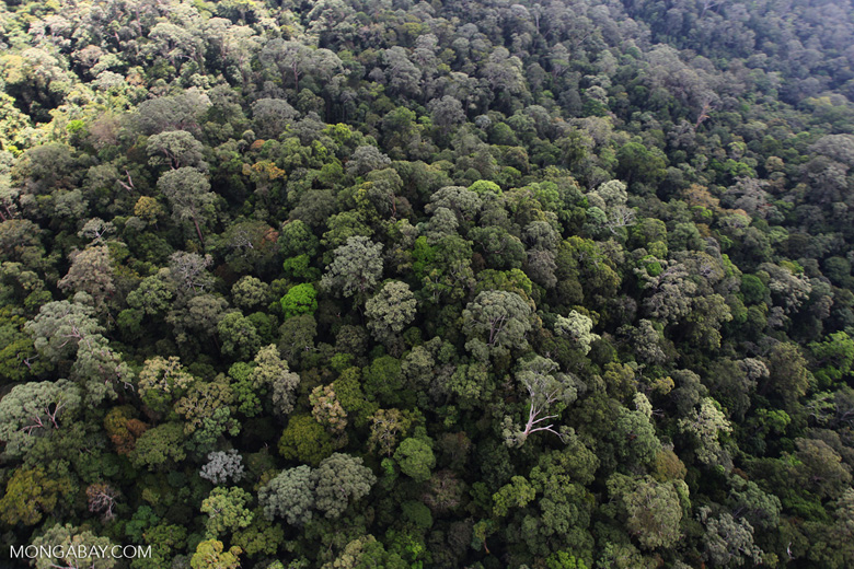
Intact forest in Sabah on the island of Borneo. Photo by Rhett A. Butler/Mongabay.
For this study, old-growth forests averaged more than 200 metric tons of carbon per hectare (89 tons per acre) and topped out at 500 metric tons in each hectare. The scientists reported their findings online Nov. 22 in the journal Biological Conservation.
As they’ve done elsewhere in the tropics, Asner and his team used a laser-based technology known as “light detection and ranging,” or LiDAR, mounted on CAO’s airplane to measure the density of carbon in nearly 30 percent of Sabah’s forests. They then combined that data with satellite imagery of the region and built a statistical model to extrapolate their findings to all of the Malaysian state’s forests.
In the end, they came up with a “wall-to-wall” map of carbon stocks in Sabah down to 30-meter (98-foot) resolution, or about 5,500 percent finer resolution than mapping that others have done on a global scale, Asner said.
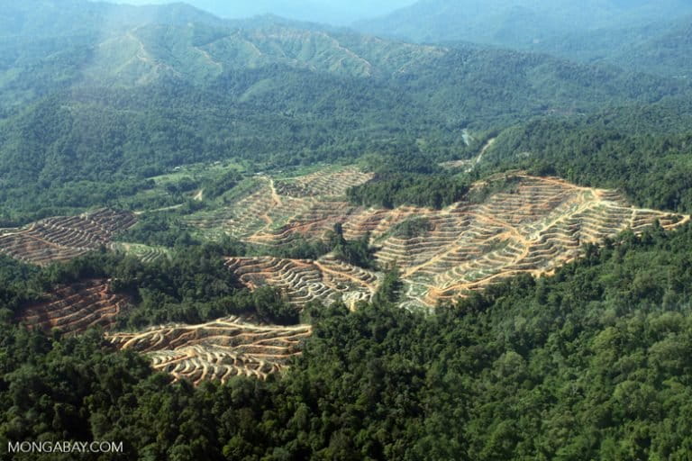
Many of Sabah’s degraded forests still pack substantial amounts of carbon, despite a long history of logging in Sabah, as well as a substantial amount forest that has been cleared for oil palms. Sabah’s oil palm plantations produce 10 percent of the world’s supply.
The researchers found that Sabah’s logged forests still hold large amounts of carbon. Photo by Rhett A. Butler/Mongabay.
Areas that had been logged still had carbon stocks as high as 140 metric tons per hectare (62.5 tons per acre).
“[That] tells me that these logged forests are important current habitat,” Asner said, “and they could become even more important if allowed to recover.”
The government of Sabah and a consortium of NGOs are working to bring all of the palm oil exported from Sabah up to the standards of the Roundtable on Sustainable Palm Oil by 2025. Cynthia Ong, head of the NGO Land Environment Animals People (LEAP), is at the forefront of this effort, and LEAP is one of the organizations “playing a vital role in connecting the science to conservation action,” Asner said.
Ong recently wrote a report indicating that Asner’s team of scientists from CAO was working with researchers on the ground in Sabah to validate the latest findings. Their hope is that the data can contribute to the identification of high-carbon stock areas that would be “no-go” zones for oil palm under the state’s new certification standards.
Results of the research could help biologists understand how animal populations and carbon stocks are correlated. Photo by John C. Cannon/Mongabay.
Asner is also working with wildlife biologists to figure out how these stores of carbon link up with the biodiversity they contain, such as the orangutans (Pongo pygmaeus) and elephants (Elephas maximus borneensis) still found in parts of Sabah.
Along with biodiversity levels, this new carbon data is helping the Sabah Forestry Department work out “where to place new maximum protections,” Asner said. The forestry department has set a goal of raising the proportion of protected land area in Sabah from 25 percent to 30 percent by the year 2025.
At the same time, Asner found in this study that around 40 percent of the areas with the most carbon don’t lie in areas with the strongest protections. That discovery creates a new opportunity to zero in on the most valuable forests to safeguard. Setting those areas aside would help lock away carbon and shore up wildlife habitat, but they also serve as a hedge against the uncertainty of rising global temperatures, Asner said.
“One big worry … is climate change,” he added. “It is thought that increasing temperatures and/or drought could reduce carbon stocks and also push animals out of current forested areas.
“This is an important reason for Sabah’s interest in expanding the network of protected areas — to allow for change.”
Deforestation for oil palm in Sabah. Photo by Rhett A. Butler/Mongabay.
CITATIONS
Asner, G. P., Brodrick, P. G., Philipson, C., Vaughn, N. R., Martin, R. E., Knapp, D. E., … & Stark, D. J. (2018). Mapped aboveground carbon stocks to advance forest conservation and recovery in Malaysian Borneo. Biological Conservation, 217, 289-310.
Banner image of elephants in Sabah by John C. Cannon/Mongabay.
FEEDBACK: Use this form to send a message to the author of this post. If you want to post a public comment, you can do that at the bottom of the page.


No comments:
Post a Comment