1
Department of Aquatic Sciences and Assessment, Swedish University of Agricultural Sciences, SE-75007 Uppsala, Sweden
2
Department of Wildlife, Fish, and Environmental Studies, Swedish University of Agricultural Sciences, SE-90183 Umeå, Sweden
3
Department of Forest Resource Management, Swedish University of Agricultural Sciences, SE-90183 Umeå, Sweden
*
Author to whom correspondence should be addressed.
Academic Editors: Farid Melgani, Francesco Nex, Jose Moreno, Clement Atzberger and Prasad S. Thenkabail
Received: 3 May 2016 / Revised: 22 August 2016 / Accepted: 29 August 2016 / Published: 1 September 2016
(This article belongs to the Special Issue Recent Trends in UAV Remote Sensing)
Abstract
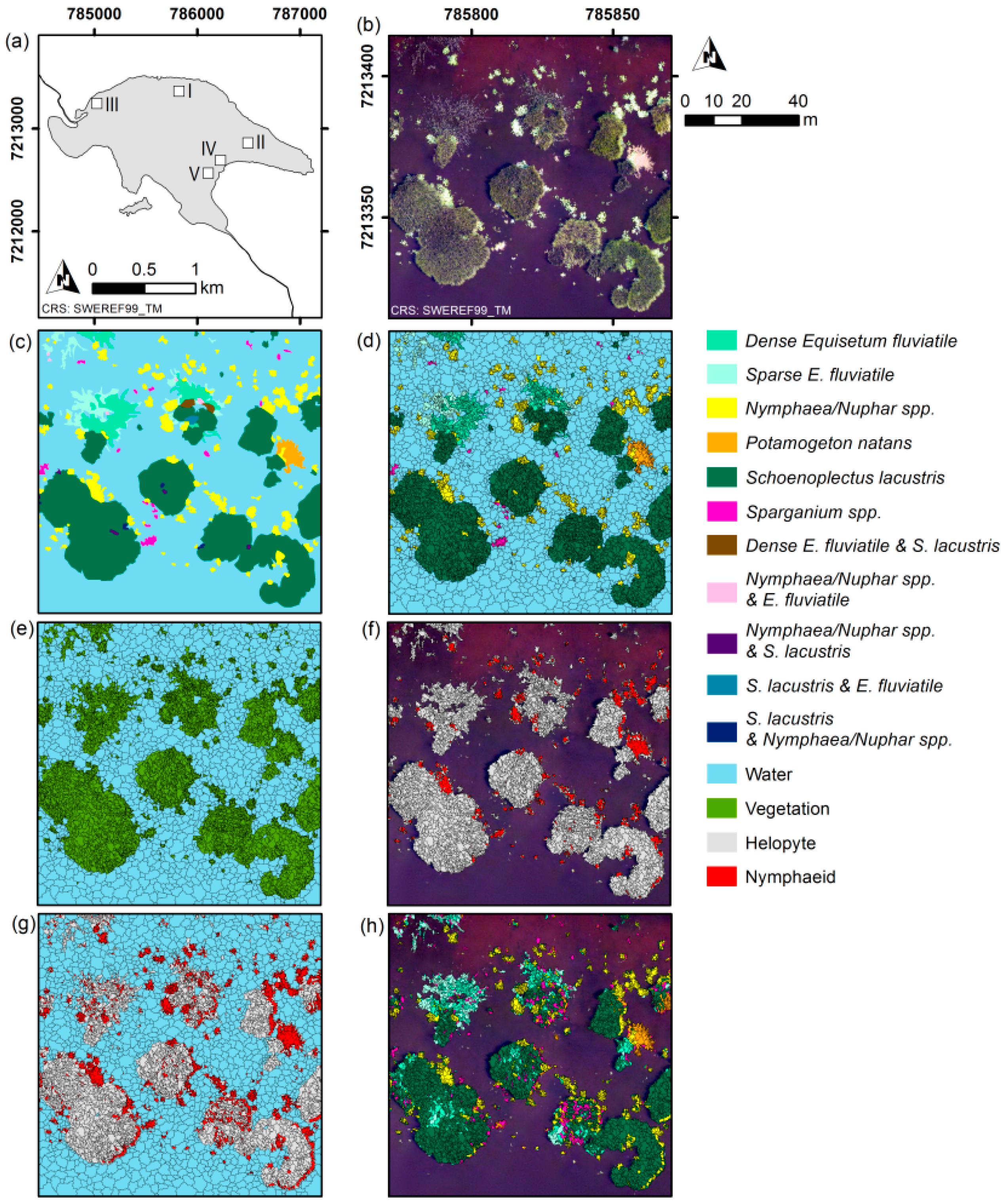
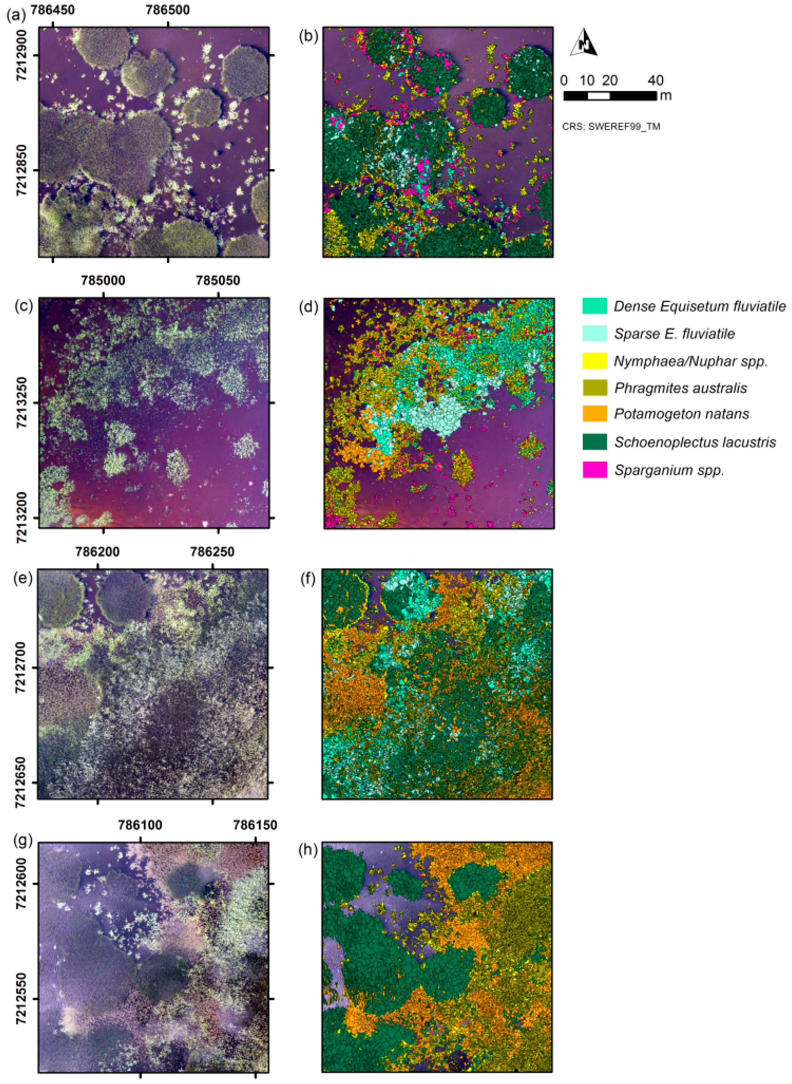
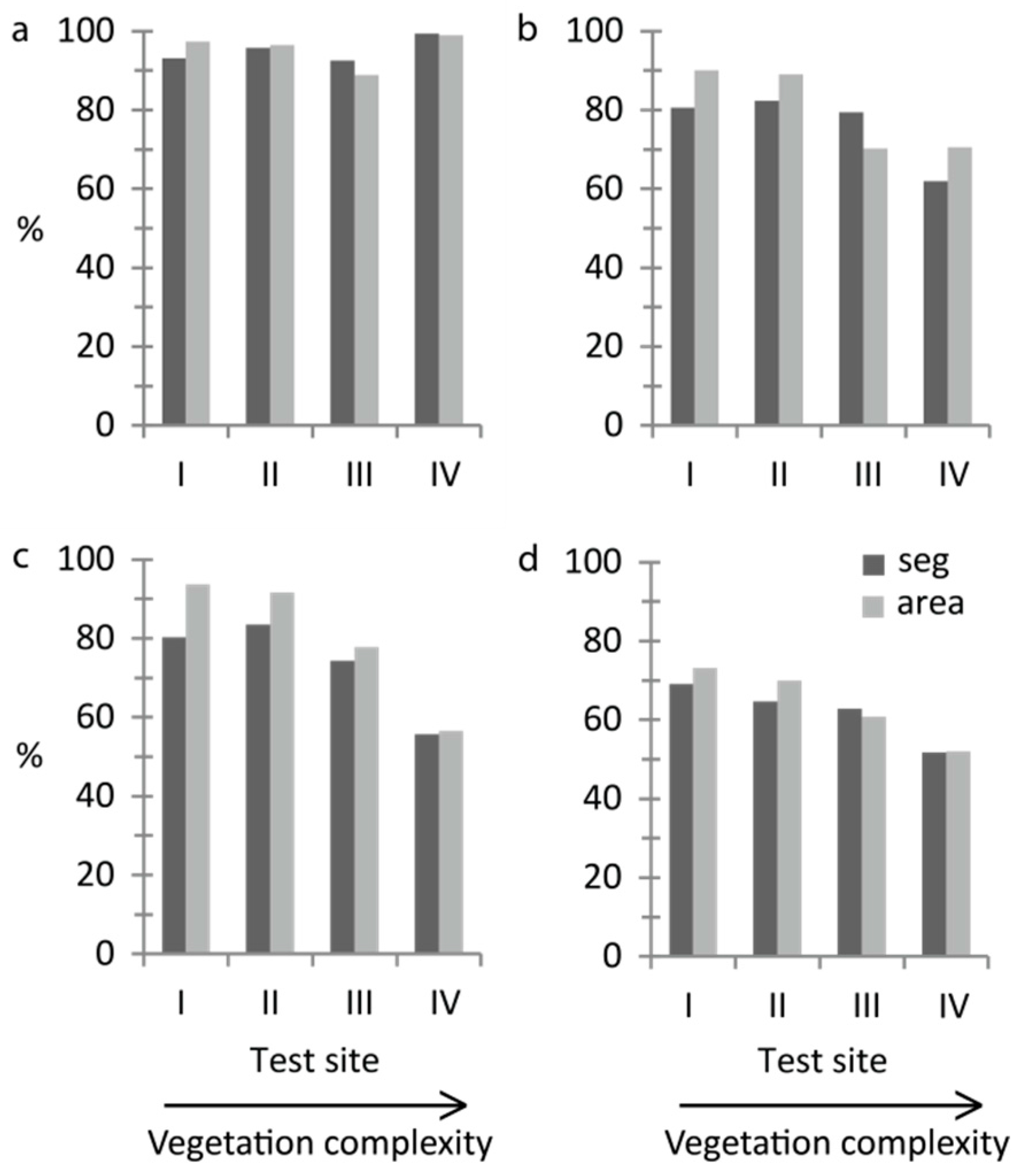
Aquatic vegetation has important ecological and regulatory functions and should be monitored in order to detect ecosystem changes. Field data collection is often costly and time-consuming; remote sensing with unmanned aircraft systems (UASs) provides aerial images with sub-decimetre resolution and offers a potential data source for vegetation mapping. In a manual mapping approach, UAS true-colour images with 5-cm-resolution pixels allowed for the identification of non-submerged aquatic vegetation at the species level. However, manual mapping is labour-intensive, and while automated classification methods are available, they have rarely been evaluated for aquatic vegetation, particularly at the scale of individual vegetation stands. We evaluated classification accuracy and time-efficiency for mapping non-submerged aquatic vegetation at three levels of detail at five test sites (100 m × 100 m) differing in vegetation complexity. We used object-based image analysis and tested two classification methods (threshold classification and Random Forest) using eCognition®. The automated classification results were compared to results from manual mapping. Using threshold classification, overall accuracy at the five test sites ranged from 93% to 99% for the water-versus-vegetation level and from 62% to 90% for the growth-form level. Using Random Forest classification, overall accuracy ranged from 56% to 94% for the growth-form level and from 52% to 75% for the dominant-taxon level. Overall classification accuracy decreased with increasing vegetation complexity. In test sites with more complex vegetation, automated classification was more time-efficient than manual mapping. This study demonstrated that automated classification of non-submerged aquatic vegetation from true-colour UAS images was feasible, indicating good potential for operative mapping of aquatic vegetation. When choosing the preferred mapping method (manual versus automated) the desired level of thematic detail and the required accuracy for the mapping task needs to be considered. View Full-Text
Keywords: aquatic vegetation; drone; growth form; object-based image analysis (OBIA); random forest; remotely piloted aircraft system (RPAS); species identification; sub-decimetre spatial resolution; unmanned aerial vehicle (UAV); unmanned aircraft system (UAS)
▼ Figures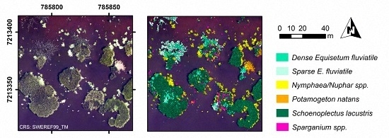
This is an open access article distributed under the Creative Commons Attribution License which permits unrestricted use, distribution, and reproduction in any medium, provided the original work is properly cited. (CC BY 4.0).
For further details log on website :
http://www.mdpi.com/2072-4292/8/9/724


No comments:
Post a Comment