Agriculture 2014, 4(2), 113-131; doi:10.3390/agriculture4020113
Author
1
ICRISAT, Patancheru-502324, India
2
National Institute of Rural Development, Rajendranagar, Hyderabad-500068, India
3
US Geological Survey (USGS), Flagstaff, AZ 86001, USA
4
Sairam Engineers, Bangalore- 560037, India
5
Spatial Information Technology, Jawarharlal Nehru Technological University, Hyderabad-500072, India
*
Author to whom correspondence should be addressed.
Received: 6 January 2014 / Revised: 19 March 2014 / Accepted: 14 April 2014 / Published: 25 April 2014
(This article belongs to the Special Issue Spectral Reflectance and Fluorescence Measurements of Crop Performance)
Abstract
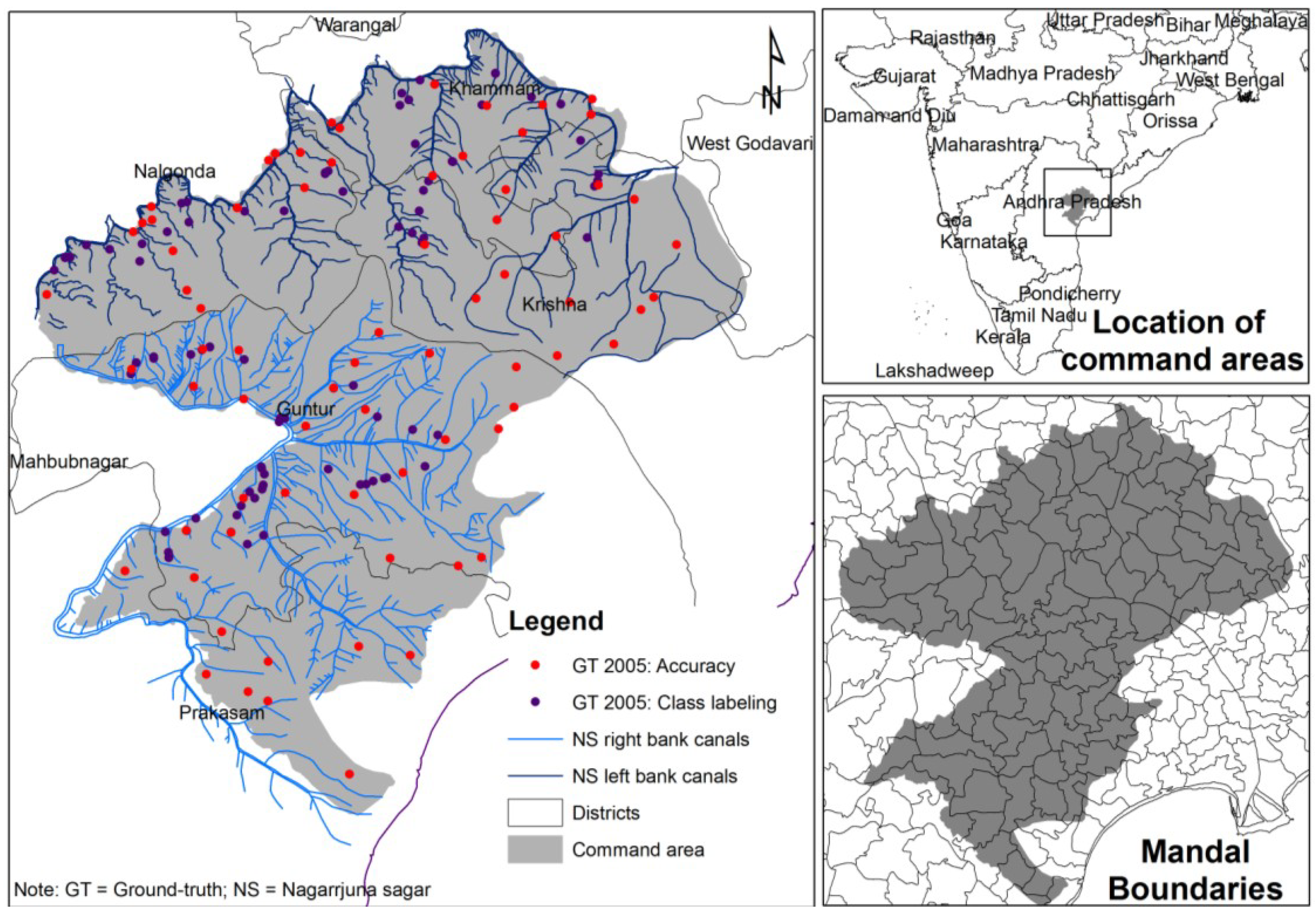
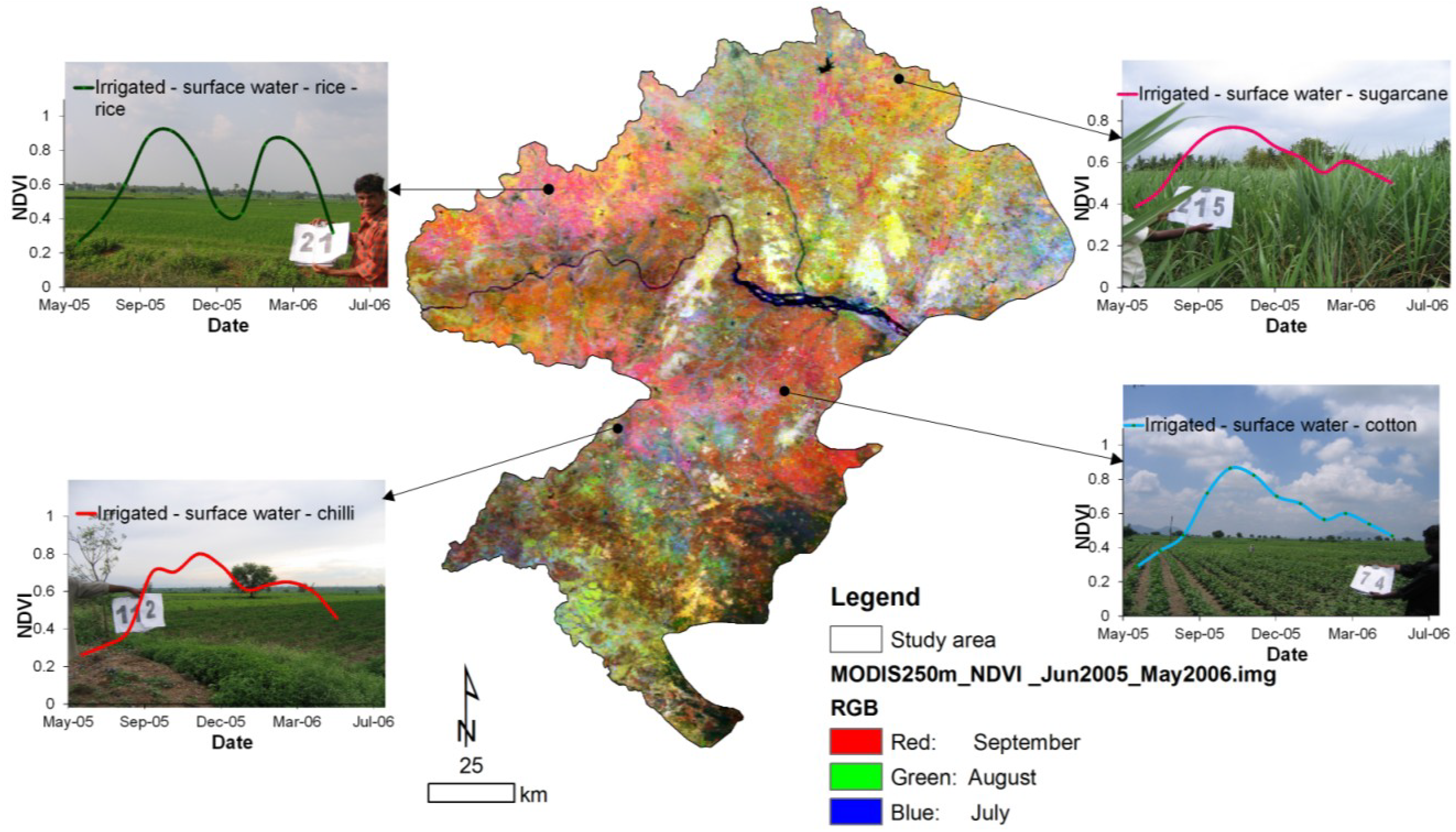
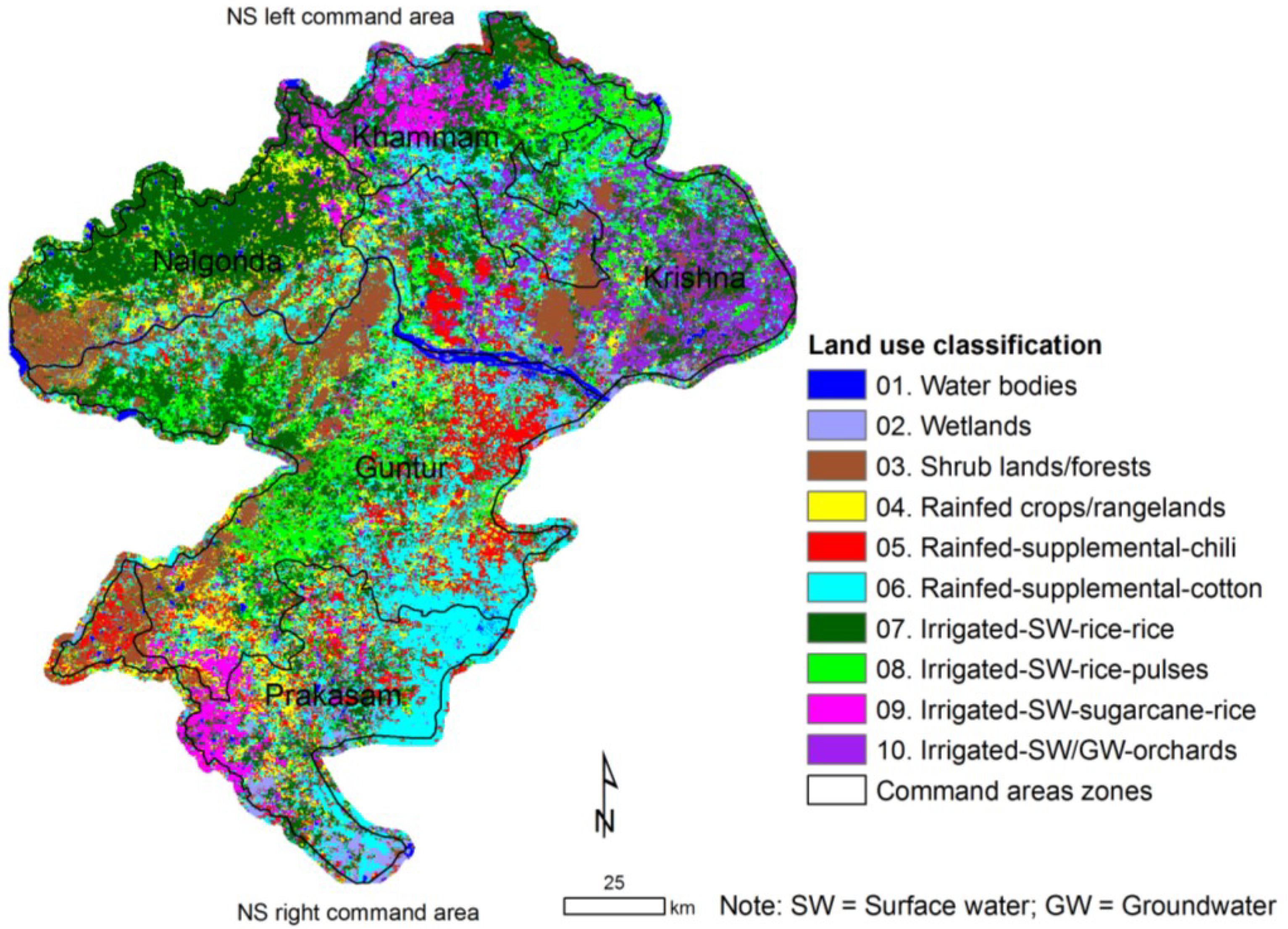
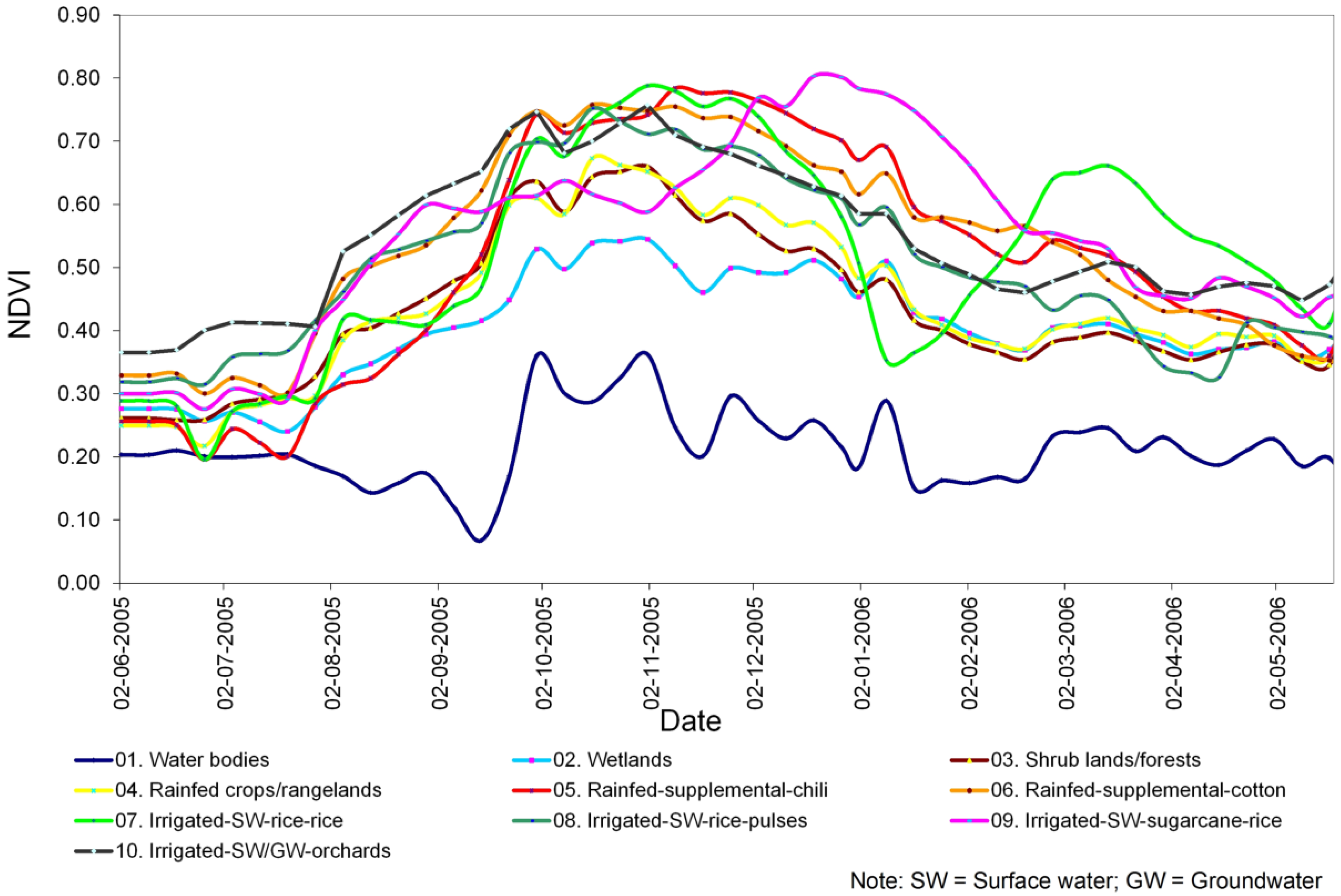
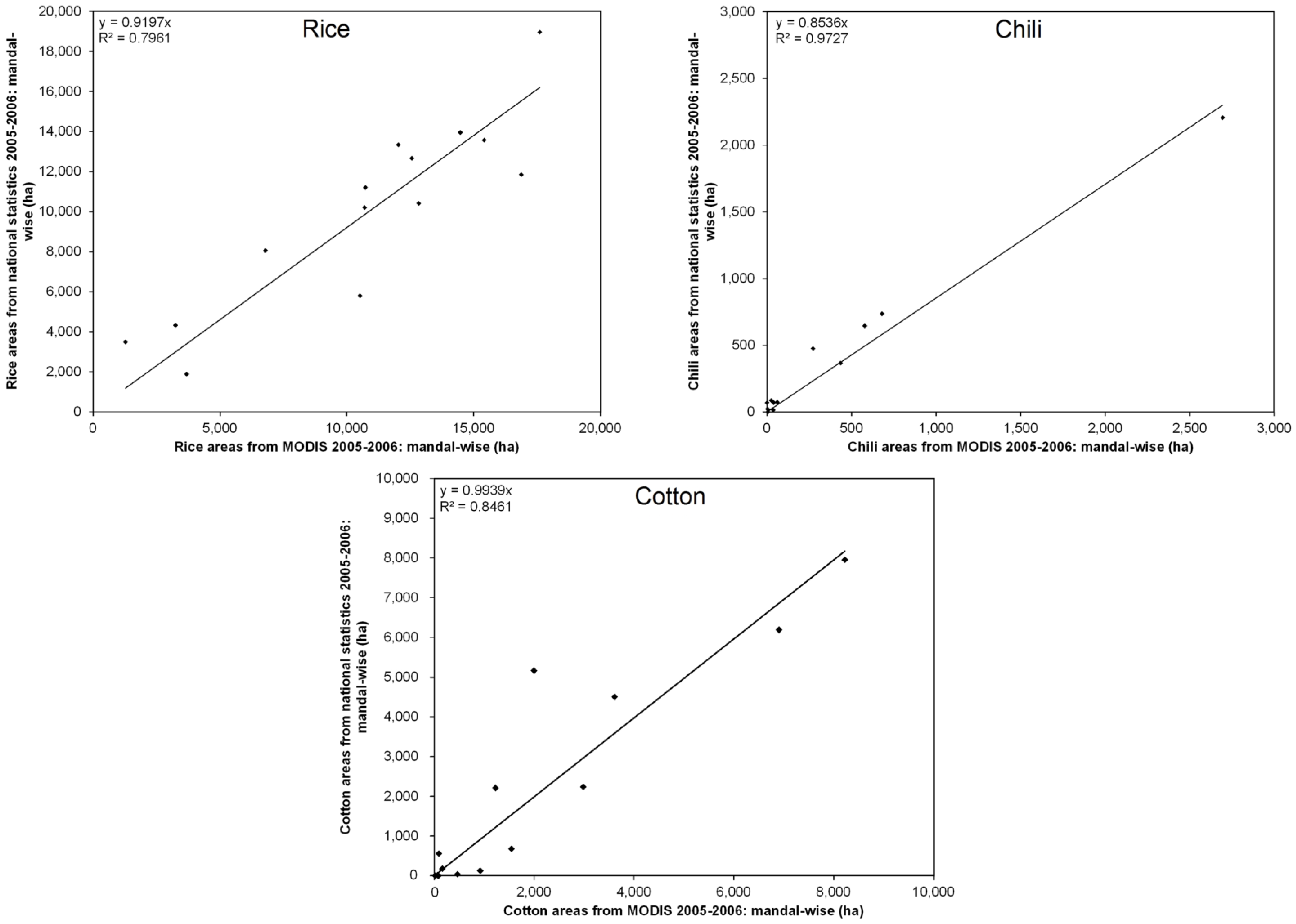
This paper describes an approach to accurately separate out and quantify crop dominance areas in the major command area in the Krishna River Basin. Classification was performed using IRS-P6 (Indian Remote Sensing Satellite, series P6) and MODIS eight-day time series remote sensing images with a spatial resolution of 23.6 m, 250 m for the year 2005. Temporal variations in the NDVI (Normalized Difference Vegetation Index) pattern obtained in crop dominance classes enables a demarcation between long duration crops and short duration crops. The NDVI pattern was found to be more consistent in long duration crops than in short duration crops due to the continuity of the water supply. Surface water availability, on the other hand, was dependent on canal water release, which affected the time of crop sowing and growth stages, which was, in turn, reflected in the NDVI pattern. The identified crop-wise classes were tested and verified using ground-truth data and state-level census data. The accuracy assessment was performed based on ground-truth data through the error matrix method, with accuracies from 67% to 100% for individual crop dominance classes, with an overall accuracy of 79% for all classes. The derived major crop land areas were highly correlated with the sub-national statistics with R2 values of 87% at the mandal (sub-district) level for 2005–2006. These results suggest that the methods, approaches, algorithms and datasets used in this study are ideal for rapid, accurate and large-scale mapping of paddy rice, as well as for generating their statistics over large areas. This study demonstrates that IRS-P6 23.6-m one-time data fusion with MODIS 250-m time series data is very useful for identifying crop type, the source of irrigation water and, in the case of surface water irrigation, the way in which it is applied. The results from this study have assisted in improving surface water and groundwater irrigated areas of the command area and also provide the basis for better water resource assessments at the basin scale. View Full-Text
Keywords: irrigated area mapping; crop dominance; Krishna Basin; remote sensing; Nagarjuna Sagar; command area; NDVI and MODIS 250 m
This is an open access article distributed under the Creative Commons Attribution License (CC BY 3.0).
For further details log on website :
http://www.mdpi.com/2077-0472/4/2/113?utm_source=TrendMD&utm_medium=cpc&utm_campaign=Agriculture_TrendMD_0


No comments:
Post a Comment