1
Faculty of Agriculture, Kyushu University, 6-10-1 Hakozaki, Fukuoka 812-8581, Japan
2
Geomatics, Remote Sensing and Land Resources Laboratory, Department of Geography, Trent University, 1600 West Bank Drive Peterborough, Ontario K9J 7B8, Canada
3
Department of Environmental and Resource Studies/Science, Department of Geography, and Office of the President, Trent University, 1600 West Bank Drive Peterborough, Ontario K9J 7B8, Canada
4
Canadian Forest Service (Pacific Forestry Centre), Natural Resources Canada, 506 West Burnside Road, Victoria, British Columbia V8Z 1M5, Canada
5
Faculty of Agriculture, Kagoshima University, Korimoto 1-21-24, Kagoshima 890-8580, Japan
6
Department of Forest Management, Forestry and Forest Products Research Institute, Matsunosato 1, Tsukuba 305-8687, Japan
7
Hokkaido Research Center, Forestry and Forest Products Research Institute, Hitsujigaoka 7, Toyohiraku, Sapporo 062-8516, Japan
8
Asia Air Survey Co., LTD, Shinyuri 21 Building, 1-2-2 Manpukuji, Asao-ku, Kawasaki 215-0004, Japan
9
Forest-Wildlife Research and Development Institute, Forestry Administration, Khan Sen Sok, Phnom Penh 12157, Cambodia
†
These authors contributed equally to this work.
*
Author to whom correspondence should be addressed.
Received: 9 July 2014 / Revised: 3 October 2014 / Accepted: 8 October 2014 / Published: 6 November 2014
Abstract
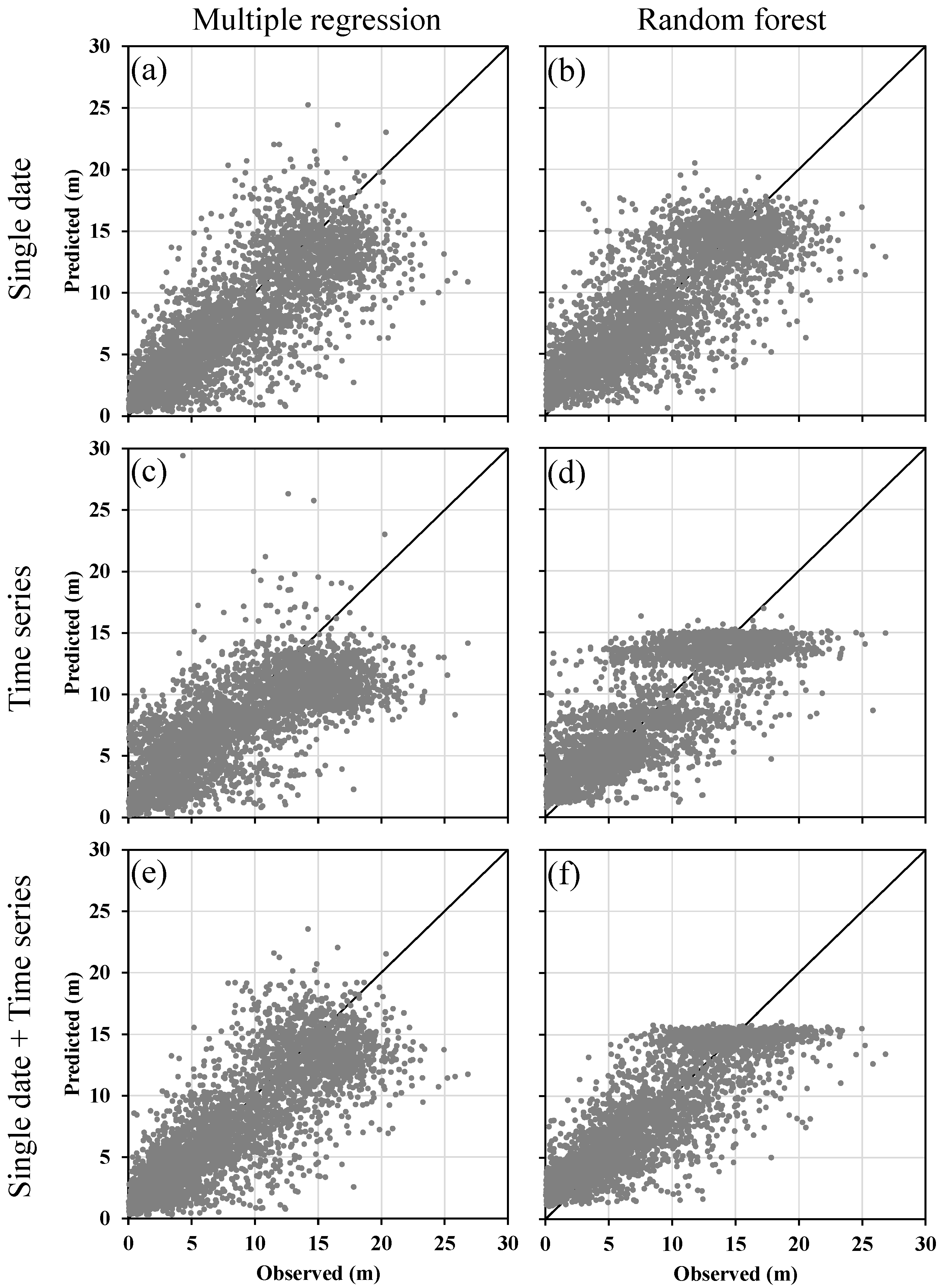
In this study, we test and demonstrate the utility of disturbance and recovery information derived from annual Landsat time series to predict current forest vertical structure (as compared to the more common approaches, that consider a sample of airborne Lidar and single-date Landsat derived variables). Mean Canopy Height (MCH) was estimated separately using single date, time series, and the combination of single date and time series variables in multiple regression and random forest (RF) models. The combination of single date and time series variables, which integrate disturbance history over the entire time series, overall provided better MCH prediction than using either of the two sets of variables separately. In general, the RF models resulted in improved performance in all estimates over those using multiple regression. The lowest validation error was obtained using Landsat time series variables in a RF model (R2 = 0.75 and RMSE = 2.81 m). Combining single date and time series data was more effective when the RF model was used (opposed to multiple regression). The RMSE for RF mean canopy height prediction was reduced by 13.5% when combining the two sets of variables as compared to the 3.6% RMSE decline presented by multiple regression. This study demonstrates the value of airborne Lidar and long term Landsat observations to generate estimates of forest canopy height using the random forest algorithm. View Full-Text
Keywords: Landsat time series; airborne Lidar; canopy height; random forest
▼ Figures
This is an open access article distributed under the Creative Commons Attribution License which permits unrestricted use, distribution, and reproduction in any medium, provided the original work is properly cited. (CC BY 4.0).
For further details log on website :
http://www.mdpi.com/2072-4292/6/11/10750


No comments:
Post a Comment